Just picking this one up again as I'd just seen a post about it on facebook and read these comments “Our charts are much more accurate than the CAA chart” and “a zoomed-in CAA chart would not be helpful as it doesn't have that kind of resolution.”
I’m not sure the Skydemon chart zooms that well as thevector lines have pretty poor resolution and, to keep performance up, fewer ground features are depicted. The reasons are understandable and I like the Skydemon chart but I think there is a tendency to be a little dismissive of the use of the CAA charts. Runway HD seems to do alright offering the CAA 1:500kchart as a separate map subscription. If only it was available on Android!
The Skydemon chart may be “more accurate” but not necessarily as clear in every aspect. While it’s true that its generally less cluttered and has better contrast (well perhaps the SD styles) there are areas where things could be improved for the Skydemon chart in CAA style....
Airspace step-downs are not as clear. The CAA chart visually highlights which sideof the intermediate line is within controlled airspace.
Airspace is not shown as clearly in some parts of the country. It may be accurate but the chart appears cluttered. Particularly for class A between Birmingham and Brize. OK you can hide features above but if you’re trying to get Skydemon CAA style chart to depict something like the CAA chart you end up with a mess or red lines. Only the external extents of the class A is relevant on a VFR chart. The line separating M605 from Daventry CTA is not necessary.
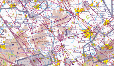
Reducing the airspace removal level to say 6500 yields some surprising differences between CAA and Skydemon as to what is in or out of class A. One may be more accurate than the other but they're different and surely there shouldn't be.
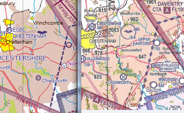
Airfield name text size / placement could be improved at 1:500k. Its interesting zooming in and seeing which labels seem to stop other labels showing. At 750k Fairford (military and not open to us civil VFR types) seems to block Kemble but at 500k Down Ampney (disused) blocks Fairford. Whats the logic for which has priority?
Not all danger / restricted areas are named and the larger areas like D123 are not named as clearly in that the name follows an edge instead of being clearly within the area. This is made worse when smaller text is obliterated by the boundary hatching. This is less apparent in the Skydemon style because of color contrast. Perhaps a bold font in the CAA style would help.
Masts / Lit Masts symbols not as clear.
VRP naming not as clear
Motorways not named and service stations junctions are not clearly shown. This could be an optional layer under terrain features.
Fewer villages and hamlets shown. Have an option turn show /hide villages and hamlets less that 1km2if necessary but currently which yellow circles are shown seems to be a bit random.
Fewer roads and water courses shown. Again,could be an option to show minor roads or when zoomed in to equivalent of say the 1/4mil chart (personally not that fussed about this).
Some towns and large villages not named. Which ones are not named does not appear to be connected to size or level of zoom.
The visual contrast of wooded areas is not as clear. The shade of green needs adjusting or perhaps edge in a slightly darker shade.
How about a user customizable chart style??